At the risk of jinking our snow chances tonight and the rest of the week, which seems to be a pattern lately, here’s the latest snowfall forecast model through the week ending Saturday morning.

GFS Model Snow Forecast Monday – Saturday
Computer models are showing two clippers with one tonight and another Wednesday night/Thursday. Tonight’s should be the strongest with 3-5″ likely and as of now a 1-3″ for the second. So it’s certainly possible to start next weekend with 6″ of fresh snow.
The trails DESPERATELY need snow! The little bit Friday night helped but the warmth on Sunday got the trails dirty really quick.
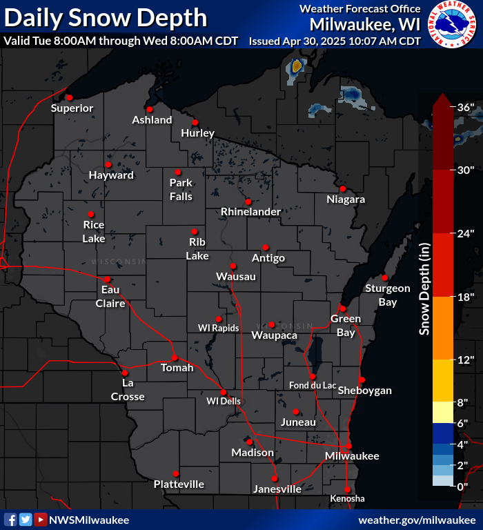
I’ve heard good reports from northern Wood and Marathon counties. While we only saw an inch Friday night, just to our north saw 3″ or 4″. You can see the difference in this snow depth map which is updated daily on the side bar.

NWS Snow Depth 1/13/14
We added a vintage rally to the Radar Run this year!
There is no cost to bring your vintage sled to show off and ride. There will be a short (~4 miles) trail ride followed by voting for the “Best in Show” trophy.